

Quick Bits:
Gates of the Arctic National Park is one of the most rugged, raw, and remote national parks in the United States. Located entirely north of the Arctic Circle in Alaska, this vast expanse covers more than 8 million acres. It remains untouched by roads, trails, or established campsites.
Visitors come here to experience wild Alaska in its purest form. They hike across tundra, paddle rivers with no names, and walk the same paths as the caribou and wolves that have roamed the land for centuries. This is a place where silence is the soundtrack and the sky stretches wide over ancient mountains.

Image by: Paxson Woelber – Via Wikipedia
Key Highlights
- Total Area: 8.4 million acres
-
Established: December 2, 1980
-
Location: Northern Alaska
-
Unique Features: Arctic tundra, Brooks Range, Kobuk and Noatak Rivers
-
Access: By air only, typically from Fairbanks or Bettles
-
Notable Wildlife: Grizzly bears, moose, caribou, wolves, Dall sheep, arctic foxes
-
Activities: Backpacking, wilderness camping, packrafting, wildlife viewing, photography.
General Information
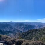
Gates of the Arctic is more than a national park. It is a living testament to survival, adaptation, and natural beauty. Named by wilderness advocate Bob Marshall in the 1930s, the park gets its title from two granite peaks—Frigid Crags and Boreal Mountain—that form a passage into the Arctic’s heart.
This park doesn’t cater to convenience. There are no visitor centers within its boundaries. No marked campsites or designated routes guide explorers. What exists here is open terrain, alpine ridges, and valley floors waiting to be discovered.
Backcountry permits are not required, though it is wise to register travel plans with the National Park Service. This helps rangers provide emergency assistance if necessary.

Image by: NPS/Josh Spice – Via nps.gov
Geography Information
Set in the Brooks Range of northern Alaska, Gates of the Arctic stretches across boreal forests, glacial valleys, and expansive tundra. The region is bisected by the Continental Divide, sending rivers flowing to both the Arctic Ocean and the Bering Sea.
Six major rivers carve through the park:
-
Alatna River
-
John River
-
Koyukuk River (North and South Forks)
-
Noatak River
-
Kobuk River
-
Tinayguk River
These waterways serve as natural highways for wildlife and floatplanes alike. The terrain features both rugged ridgelines and gentle valley floors. Elevations range from about 500 feet in lowland basins to over 7,000 feet in the highest mountain peaks.
Permafrost lies under much of the land. Summer brings brief blooms of mosses, wildflowers, and lichens. Winters cloak the land in white silence.

Image by: Sherman Hogue– Via Alaskatours.com
Places to Visit
While the park lacks roads and infrastructure, there are several notable regions that capture its essence.
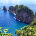
1. Arrigetch Peaks
Jagged granite spires that rise like teeth from the tundra. Popular with climbers and photographers alike, the area is rich in alpine beauty. Reached by bush plane and several days of backpacking.
2. Lake Matcharak
A scenic spot perfect for floatplane access and basecamp-style camping. Moose, loons, and bears frequent this clear lake.
3. Alatna River Valley
Gentle slopes and wide vistas make this a choice destination for trekking and river trips. The river winds through forest, tundra, and steep canyon walls.
4. Anaktuvuk Pass
Home to the Nunamiut people, this small village within the park offers insight into Inupiat culture and a glimpse of modern Arctic life.
5. Walker Lake
A stunning alpine lake set against a mountain backdrop. Great for kayaking and fishing.
Each of these places requires effort and preparation to reach, but the rewards are immense—solitude, silence, and a deep connection to untouched earth.

Image by: Paxson Woelber – Via Wikipedia
Yearly Climate
Life in the Arctic is dictated by the seasons. Conditions shift fast, with temperature swings that test both nature and visitors.
Winter (October to April)
-
Conditions: Extreme cold, often below -40°F
-
Daylight: Limited, often only a few hours
-
Activities: Very limited; mainly scientific and survival-based expeditions
Spring (May)
-
Conditions: Ice begins to thaw, temperatures remain chilly
-
Access: Airstrips open up slowly
-
Wildlife: Bears emerge, migratory birds return
Summer (June to August)
-
Conditions: Daylight dominates with 24-hour sun
-
Temperature: Ranges from 45°F to 75°F
-
Access: Best time for flights, hiking, river trips
-
Bugs: Mosquitoes can be intense
Fall (September)
-
Conditions: Colors peak, frost returns
-
Wildlife: Caribou migration in full swing
-
Temperature: Drops rapidly into freezing range.
Best Time of Year to Visit
Mid-June through early September offers the best window for experiencing Gates of the Arctic. This is when daylight stretches endlessly and access is most reliable. Rivers flow freely, the tundra bursts into bloom, and wildlife is active.
July brings warmest days. August unveils fiery autumn colors across the tundra. If planning a trip, allow at least a week for exploration, factoring in flight logistics and potential weather delays.
River travelers favor late June and July for optimal water levels. Backpackers seek July for clearer trails. Late August, though colder, offers fewer bugs and stunning color.

Image by: Paxson Woelber – Via Wikipedia
In Summary…
Gates of the Arctic National Park stands alone. Not just because of its remote location or lack of roads, but because of what it represents. A place where nature shapes every experience. A place where silence has weight and meaning.
From the peaks of the Arrigetch to the quiet flows of the Alatna, the park invites those who are prepared. It is not a park for passive observers. It demands attention, care, and respect.
To step into this wilderness is to step back in time. To understand the world before maps, fences, and engines. It is one of the last true wild places left.


.jpg)